
An Open Letter to Texas Politicians:
During the past year, many of us have submitted letters to our elected representatives expressing our concerns regarding the manner in which the Border Wall or Fence is being constructed in the Lower Rio Grande Valley (LRGV). Most of our letters of concern have gone unanswered although we have received a few vague responses which appear to be standard form letters which have little or no relevance to the concerns we expressed. This indicates to us that our letters are not getting past your staffers, so we are expressing these concerns again by way of this Open Letter to Texas Politicians, which includes all of our Senators and Representatives in the U. S. Congress, the Governor of Texas, and our local County officials involved in the Border Wall project.
One of the primary concerns expressed in our previous letters relates to the fact that construction of the Border Wall in Hidalgo County was originally scheduled to begin on 25 July 2008 – a date which lies in the middle of our annual hurricane season. Less than one week after letters requesting a congressional investigation or reevaluation of the Border Wall project in south Texas were sent to Mr. Richard Stana of the Government Accountability Office in Washington (with copies to both Texas Senators), the LRGV region was impacted by Hurricane Dolly, a category 2 storm which made landfall on 23 July and caused extensive flooding in most of Cameron County and within large areas of central Hidalgo County. Approximately two days after the landfall of Hurricane Dolly, and while Dolly’s floodwaters were still rising in most areas of the LRGV region, DHS contractors began excavating the flood-control levees at Granjeno for implantation of the concrete Border Wall. Since that time, additional large-scale construction projects have been initiated along levee systems located east of Santa Ana NWR near Alamo and south of Donna and Weslaco. It does not seem to have dawned on any of the decision-makers in the Border Wall project that we are still in the middle of our annual hurricane season, and they seem to be oblivious to the fact that NOAA has warned that 2008 will probably be an unusually active hurricane season.
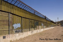
To appreciate why we are so concerned about this situation, please note the images of the flood-control levees at Granjeno (located four miles south of Mission) which were acquired on 1 September 2008 – the same day that Hurricane Gustav made landfall on the Louisiana coast. The first two images were taken from the back yard of a local resident and show the north face of a levee under construction – notice how loose and friable the soil on this side of the levee appears to be, which suggests that it has been destabilized to a considerable extent as a result of construction activities.


North face of flood-control levee at Granjeno, Texas – 1 September 2008.
When this same section of the Granjeno levee system is viewed from the floodway located to the south, several disturbing observations are evident. First, the extent of Border Wall construction which has occurred in this area during the past six weeks – i.e., since 27 July - is substantial, although the concrete Border Wall itself appears to be far from complete (upper). More importantly, a huge gap exists between the concrete Border Wall and the south face of the original (now excavated) levee which shows the same evidence of destabilization (loose and friable texture) as the north side discussed previously (lower). After viewing these images, try to visualize how a “flood-control” levee in this destabilized condition might perform if we are impacted by another hurricane this year and areas such Granjeno are subjected to torrential rainfall and the floodway to the south becomes submerged in deep water exhibiting strong currents and eddies. By doing so, you will probably begin to understand why we are so concerned about this situation and why we are making so much noise about it.


South Side of the Granjeno levees – 1 September 2008.
In a meeting held in Edinburg during early-June of this year, our local Hidalgo County officials assured us that construction of the Border Wall will not destabilize our flood-control levees in any manner - they even stated that levees under construction would be checked and certified as being stable (at least 15 of our members were present at this meeting and can verify that these statements were made). Ladies and Gentlemen – Senators, Representatives, Governor, and Locals - it does not take a rocket scientist or a hydrologist or a civil engineer to figure out that the “flood-control” levees shown in the above images are in a highly destabilized condition as a result of Border Wall construction and will probably not hold up to runoff produced by a heavy afternoon thundershower, much less to floodwaters produced by a major tropical storm or hurricane. This is a very dangerous situation – we have already been impacted by one hurricane this season and recent NOAA satellite images of the Atlantic, Caribbean and Gulf of Mexico resemble an “assembly line” of tropical storms and hurricanes, any one of which could head our way. If this occurs, we will have a week at most to prepare for it, and we see no way that destabilized “Humpty-Dumpty” levees such as those that now occur at Granjeno and other areas can be “put back together again” in time to avert major flooding.
In a meeting held in Edinburg during early-June of this year, our local Hidalgo County officials assured us that construction of the Border Wall will not destabilize our flood-control levees in any manner - they even stated that levees under construction would be checked and certified as being stable (at least 15 of our members were present at this meeting and can verify that these statements were made). Ladies and Gentlemen – Senators, Representatives, Governor, and Locals - it does not take a rocket scientist or a hydrologist or a civil engineer to figure out that the “flood-control” levees shown in the above images are in a highly destabilized condition as a result of Border Wall construction and will probably not hold up to runoff produced by a heavy afternoon thundershower, much less to floodwaters produced by a major tropical storm or hurricane. This is a very dangerous situation – we have already been impacted by one hurricane this season and recent NOAA satellite images of the Atlantic, Caribbean and Gulf of Mexico resemble an “assembly line” of tropical storms and hurricanes, any one of which could head our way. If this occurs, we will have a week at most to prepare for it, and we see no way that destabilized “Humpty-Dumpty” levees such as those that now occur at Granjeno and other areas can be “put back together again” in time to avert major flooding.
In all of our previous correspondence, we have simply asked that one or more of our elected public officials take the initiative to address this problem before a genuine disaster occurs here. The solution to this problem is simple – use your influence and power or introduce legislation to postpone any further construction of the Border Wall in the LRGV region until the 2008 hurricane season ends in November. If this is not done, we are facing the distinct possibility of having 30+ miles of our flood-control levees in Hidalgo County disrupted to the extent of those at Granjeno during the most dangerous time of the year (the hurricane season peaks during mid-September). And while you are at it, you might want to assess the ramifications of the recent decision by DHS officials to construct a traditional metal Border Fence (in lieu of a concrete Border Wall) in neighboring Cameron County in order to reduce costs. What everyone involved had better be aware of is that the metal Border Fence has caused at least three major floods this year in cities located in Arizona and/or adjacent areas of Mexico - e.g., the failure of runoff from a 2-inch rain to flow under the Border Fence in Nogales, Arizona resulted in floodwaters up to 8 feet deep in neighboring Nogales, Mexico during July, 2008. If DHS mandates the construction of the less-expensive fence in Cameron County, then it is essentially mandating the construction of a structure known to be dangerous through an entire Texas county without the approval of local citizens. If things go wrong, and a lot of property is damaged and/or lives are lost because of this structure, the U. S. government will face a public relations meltdown and the local officials and contractors who constructed the fence will very probably spend their retirement years in poverty and possibly in jail.
We support efforts to secure the international border with Mexico, but we also expect and demand that government programs in our area be conducted in a manner that does not place our homes and lives at undue risk.
Thank you.
K. Rod Summy, Ph.D.
Resident and Concerned Citizen
Weslaco, Texas
We support efforts to secure the international border with Mexico, but we also expect and demand that government programs in our area be conducted in a manner that does not place our homes and lives at undue risk.
Thank you.
K. Rod Summy, Ph.D.
Resident and Concerned Citizen
Weslaco, Texas


1 comment:
Deceiving commentary on the engineering that is going on here. First the existing levees (small molehills) are raised using fill material. That is what the author calls "unstable" and "friable." Then the flood wall is constructed in front of the raised levees on the side facing the river, with space between so as not to disturb the newly upgraded eathen levee. After the wall is complete, the space is backfilled and consolidated agatinst the back of the flood wall. Please explain how the upgraded earth levee would provide less protection during a major storm than what was originally there?? (the original earth levee is still there underneath the built up levee). This makes no sense to me and it's a deceptive way to get an audience for this site's border wall bashing.
Post a Comment