Showing posts with label International Boundary Water Commission. Show all posts

Wednesday, April 24, 2013

Another Round of South Texas Border Wall Condemnations is about to Begin

By Scott Nicol


If the Border Patrol knocks on your door you might want to have a lawyer present when you answer.

That is because Customs and Border Protection is gearing up for a fresh round of land condemnations to build border walls in Roma, Rio Grande City, and Los Ebanos.

According to documents obtained by the Sierra Club through a Freedom of Information Act request the new walls won’t just slice through farmland and wildlife refuges.  In Roma “up to 25 residences could be impacted.”  In Rio Grande City the wall’s route will take it through a nursing home, and “If the decision is made to buy the tract out in its entirety, the business will need to be relocated along with 64 residents, potentially up to 90 residents if at 100% capacity.  In Los Ebanos landowners who went through condemnation three years ago will be hauled into court again to have more of their property snatched away.

This new assault on border communities is the result of the US section of the International Boundary Water Commission’s (US IBWC) decision to allow border walls to go up in the Rio Grande floodplain.

When they were first proposed, along with the rest of South Texas’ border walls, US IBWC stated categorically that walls could not be erected in the floodplain because they posed an unacceptable flood risk to communities on both sides of the river.  Walls north of the river might deflect rising flood waters, worsening the damage to Mexican cities and possibly even pushing the river into a new channel, thereby changing the location of the international border.  For this reason walls in Cameron County were erected north of the flood control levees, and in Hidalgo County there were inserted into them.


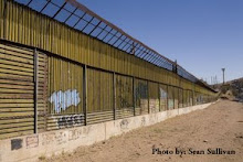
The new walls will be identical to those built in Cameron County, using six inch wide steel posts that stand eighteen feet tall with four inch spaces in between.  In 2008 Baker Engineering looked at the impacts of this design placed in these locations, and estimated that during a flood the walls would clog with debris, limiting the ability of water to pass between the pillars.  In Roma they estimated an 85% blockage where the walls paralleled the river’s flow; in Rio Grande City a 67% blockage; and in Los Ebanos a 36% blockage.  Where the walls would be erected perpendicular to the flow Baker said CBP should assume that debris would cause the walls to be completely blocked.

In 2011 Customs and Border Protection paid Baker to look at the same wall design placed in the same location, and with no new evidence or explanation they came to a radically different conclusion.  Now A debris blockage of 10% was adopted where the fence is aligned parallel to the flow and 25% at locations where the fence is aligned perpendicular to the flow.”  Not surprisingly the model that this new estimate was plugged into concluded that walls in the floodplain would not deflect or dam flood water, since 75 -90% of the water would supposedly pass right through.


The US section of IBWC accepted this without question.  The Mexican section categorically rejected it. 

One would think that a bi-national organization would require agreement before permitting potentially dangerous projects.  Instead, the new border walls are going up.

In a presentation dated March 1, 2013, Customs and Border Protection laid out a timeline for the construction of these new walls:

Funds:  already received.

Achieve right of entry to survey property for wall construction:  60 days.

Initiate new acquisitions of property, through purchase or condemnation:  180 days.

So if you have property in the path of these walls, now is the time to call a lawyer.

And those lawyers are going to be very busy.  The “gang of eight” immigration bill includes $1.5 billion for new border walls. 

When Congress passed the Secure Fence Act in 2006 Customs and Border Protection walled off big portions of California, Arizona, and New Mexico.  There aren’t too many places outside of inaccessible mountains without walls up there.  What’s left is Texas. 

Unless the bill is changed and the walls are taken out Customs and Border Protection will start filling in the unwalled spaces between South Texas’ existing border walls.  The Lower Rio Grande Valley National Wildlife Refuge, and the endangered species that it protects, will be utterly decimated.  And every other landowner with property along the Rio Grande from Roma to Boca Chica will stand in turn before a federal judge, before watching construction crews wall off their land from the river. 

Some, like the 25 households in Roma or the senior citizens in Rio Grande City, may even see the their homes fall to these new border walls.

Sunday, September 9, 2012

Will Walls Worsen Rio Grande Flooding? U.S. IBWC Can’t Give a Straight Answer


By Scott Nicol

The United States section of the International Boundary and Water Commission (US IBWC) recently hosted a meeting in Rio Grande City to explain their decision to allow Customs and Border Protection to build new border walls in the Rio Grande floodplain.  While they should be commended for reaching out to local residents, they seemed completely unprepared, unable to answer the most basic questions about their decision or the new walls.

When, for example, landowners asked whether there had been any on-the-ground surveys, and what the wall would mean for access and impacts to their property, they got no response. 

The manager for Rio Grande City’s international bridge and port of entry asked how they would be able to access the riverbank to carry out ongoing erosion control efforts.  US IBWC did not know. 

Residents asked whether walls crossing the washes that feed into the Rio Grande might become blocked with debris, preventing normal drainage and causing flooding.  At that point US IBWC admitted that even though they approved these new walls months ago, Customs and Border Protection still has not provided them with the walls’ design specifications, so they could not answer that question either.

2007 Bureau of Land Management photo of debris in the Arizona wall
 

US IBWC was also unable, or unwilling, to answer a key question about the flood model that they are using to justify their approval of border walls in the floodplain. 

Using the Freedom of Information Act the Sierra Club has gotten a copy of the flood model, as well as a number of related documents.

In 2011 Customs and Border Protection paid Baker Engineering to produce a model that claimed that flood water would pass harmlessly through the 4-inch wide spaces between the border wall’s six-inch wide bollard posts.  Baker’s accompanying report stated that, “A debris blockage of 10% was adopted where the fence is aligned parallel to the flow and 25% at locations where the fence is aligned perpendicular to the flow.”

The model’s computer program cannot add to this number, cannot decide that it is too low and that in reality more debris will clog the spaces between bollards.  By telling the computer that 75% to 90% of floodwater will pass through the wall, Baker effectively predetermined the model’s end result.    

At the meeting in Rio Grande City, surrounded by residents whose lands and lives will depend on whether or not these walls will actually let water pass through or will dam it up, US IBWC could not explain where the suspiciously round and suspiciously low estimate of 10% - 25% debris blockage came from.

In earlier reports Baker Engineering came to a very different conclusion about how much debris border walls were likely to catch.

After border walls in Arizona became clogged with debris and acted as dams in 2008, inflicting millions of dollars of damage on both sides of the border and causing two deaths, Baker Engineering was hired to follow the wall from El Paso to San Diego and report back to Customs and Border Protection.  Baker found that, PF 225 fencing obstructs drainage flow every time a wash is crossed. With additional debris build-up, the International Boundary Water Commission’s (IBWC’s) criteria for rise in water surface elevations (set at 6” in rural areas and 3” in urban areas) can quickly be exceeded.” The report included photographs of bollard-style walls nearly identical to those planned for the Rio Grande floodplain filled with debris, and documented “debris build-up which sometimes reached a height of 6 feet.

 Photo from the 2009 Baker report showing debris in the Arizona border wall

In examining on-the-ground evidence of debris clogging border walls, it bolstered a 2008 Baker Engineering white paper that looked at the likely impacts of the walls planned for Roma, Rio Grande City, and Los Ebanos.  In discussing the wall’s transfer capacity - the ability of water to pass between the bollards - it stated that,


Map of the three new border walls from the 2011 Baker flood model
 

So how did Baker’s estimates of clogging drop from 85%, 67%, and 36% down to 10% where the wall is parallel to the Rio Grande, and from 100% down to 25% where it is perpendicular?

The US IBWC has yet to give the public an answer to that question.

The new flood model, with its low debris estimate, is cited by the US section of the International Boundary and Water Commission as the basis for its decision to allow these border walls.  The Mexican section has rejected the model’s assumptions, countering in late 2011 that these walls would likely obstruct 60% - 70% of flood flows even before the clogging effect of debris is factored in. 

On February 9, 2012 the two sections of the bi-national organization met to discuss their disagreement.  Meeting notes written by the same US IBWC engineer who was unable to answer questions about the model’s assumptions at the Rio Grande City public meeting say that,


So even when they met with their Mexican counterparts, US IBWC gave no concrete evidence that the lower estimate was more accurate than the earlier, much higher one.  The nice, round, low number was \simply “felt to be reasonable”, despite conflicting with empirical evidence from Arizona, and was adopted because it matched up with the Department of Homeland Security’s desire for a model showing a “minimum debris blockage.”

Not only was Mexico’s estimate ignored, they were not even invited to participate in the 2011 modeling methodology meeting.  And six days after the 2012 meeting the US section, flouting its treaty obligations, unilaterally approved Customs and Border Protection’s request to build walls in the floodplain.


Customs and Border Protection photo of debris backed up behind the border wall

Customs and Border Protection (CBP) has not hosted a public meeting on border walls in South Texas since 2007, but they did send a representative to the recent Rio Grande City meeting.  He declined to present any information, and remained silent unless he was asked a direct question. 

When asked when CBP would begin construction he said that at this time they do not have the funds to build these walls.  He failed to mention that CBP bought the steel years ago and currently has it in storage.  More importantly, he failed to mention that the new fiscal year for federal agencies begins on October 1, at which time their bank accounts will be refilled. 

If border residents want answers, we need to demand them now. 

Representative Cuellar and Senators Hutchison and Cornyn need to pressure the US IBWC to reverse its bad decision, and direct Customs and Border Protection to finally give up on these dangerous walls.  They need to take concrete action, and they need to do it now.

But of course they won’t, unless we, their constituents and voters, tell them to.

October is only three weeks away.  The clock is ticking.

Saturday, July 21, 2012

IBWC Approves New Border Walls Despite Flood Danger

By Scott Nicol
The U.S. half of the International Boundary and Water Commission (IBWC) has finally caved under pressure from Customs and Border Protection (CBP) and approved border walls in the Rio Grande floodplain adjacent to Roma, Rio Grande City, and Los Ebanos.    

Customs and Border Protection maps of the three new Rio Grande border wall sections

These three border wall sections, totaling 14 miles, were not built when other parts of the Rio Grande Valley were walled off because of the serious danger they pose to communities on both sides of the river.  On the U.S. side they could block the exit of flood water into the Rio Grande, bottling it up in towns and farm land and exacerbating the damage that they suffer.

They could also deflect flood waters towards Mexico, worsening flooding in Mexican communities.  Deflection might even cause the river to settle into a new channel farther to the south, which would effectively change the location of the border.  

In an attempt to lessen the amount of water that these walls will deflect into Mexican cities CBP designed them to channel flood waters north into the U.S. cities that they abut.  The walls will begin close to the Rio Grande, where during a flood water would be split off from the main channel.  As the river bends the mostly straight walls get farther from them, meaning that floodwater, along with all of the debris and garbage it carries, will be channeled into properties in the United States that might otherwise be spared from flooding. 

To make certain that water is channeled into the U.S. holes were planned for the middle of two of these wall sections – a 100 foot wide gap in the Roma wall, and a 275 foot wide gap in the Rio Grande City wall – explicitly intended to direct more water into these communities during a flood.

Existing border wall slicing through the Lower Rio Grande Valley National Wildlife Refuge

All three of the new border wall sections would also slice through the Lower Rio Grande Valley National Wildlife Refuge.  Established to create a wildlife corridor along the Rio Grande, the refuge provides habitat for critically endangered ocelot and jaguarundi.  Walls that have already been erected downriver repeatedly bisect and fragment the refuge, putting the future of the terrestrial species that it harbors in doubt.  The new walls would further fragment the refuge and cut off animals from the only reliable source of water in what US Fish and Wildlife has described as “some of the best habitat(s) in the U.S. along the final portion of the Rio Grande.

In a February 15, 2012 letter John Merino, Principal Engineer for the US section of the International Boundary and Water Commission gave CBP the green light, saying, “the USIBWC has no objection to the erection of the fence segments within the limits of the Rio Grande floodplain.”  Merino dismissed the possibility that walls would deflect or obstruct flood waters, and stated flatly that USIBWC did not examine potential environmental impacts.  He also failed to mention the fact that for the previous five years both the U.S. and Mexican halves of the bi-national International Boundary and Water Commission had rejected the idea of placing border walls in the floodplain. 

Throughout 2007 and 2008 CBP tried without success to come up with a wall design for these last three sections that would not impact flooding, and that the IBWC would therefore approve.  Unable to convince the IBWC that walls in the floodplain would not act like dams, a DHS briefing from October 2, 2008, said of these three, “DHS likely to drop fence segments. When CBP informed Representative Henry Cuellar a few days after the 2008 election that these border wall sections were “on hold,” Cuellar called it “a big victory” for his district.

It would have made sense for Customs and Border Protection to decide that the Roma, Rio Grande City, and Los Ebanos walls were not worth risking lives and property to build.  Or, if bureaucracy outweighed humanity in their thinking, they might have called off wall construction in order to comply with the international treaty.

They also could have based a decision to spare them on a June 2008 internal Customs and Border Protection document that stated that The Rio Grande Valley Sector Chief has determined that operational areas that contain the PF225 fence segments such as O-1 to O-2, O-12 through O-14, and O-17 through O-21 to be in “effectively controlled” level at the current time.  Segments O-1 and O-2 are the Roma and Rio Grande City walls. 

Segments O-12 through O-14 are in Cameron County, near Los Indios.  Segments O-17 through O-21 encompass all of the wall sections in the vicinity of Brownsville, from the neighborhoods near the River Bend Golf Course west of town past the Sabal Palms Audubon Sanctuary and the Loop family orchard to the east.  Those who live in these areas and had their property condemned for border walls lost their land for nothing, because the local Border Patrol had determined that the area already under effective control before any walls were built.

Border wall segment O-21 under construction with the Sabal Palms Audubon Sanctuary south of it

Of course decisions about who will get walls and who will be spared are made in Washington DC, not the Rio Grande Valley. 

That simple fact helps to explain why Customs and Border Protection continued to push for these walls, shifting tactics from trying to convince Mexico that walls would not worsen flooding south of the border to pushing the US section of IBWC to allow for “unilateral” action – building walls in the face of Mexican objections, and thereby violating the international treaty.

After hurricane Alex roared into the Rio Grande Valley in 2010, followed by a tropical depression, the flooding Rio Grande forced the mandatory evacuation of Los Ebanos and parts of Rio Grande City.  With homes underwater and the evacuation order still in place, CBP hosted a meeting for the USIBWC and the State Department in Washington DC. 

At the DC meeting Customs and Border Protection did not mention the ongoing floods that were inundating the sites of the proposed walls, or the Border Patrol sector chief’s assessment that the area was “effectively controlled.”  Instead, CBP said that the three remaining walls were “critical to our Nation’s security,” and since Mexico continued to insist that they posed a flood hazard “we need [US]IBWC and Department of State’s support for an unilateral decision to proceed with the fence construction.”

Throughout 2010 USIBWC consistently rejected unilateral action, pointing out the likelihood of “substantial increases in water surface elevations and deflections of flow at several points of all three projects.”

But in late 2011 USIBWC reversed itself.  John Merino, the US section’s Principal Engineer, wrote to his Mexican counterpart to say that US IBWC had “concluded that the project will not cause significant deflection or obstruction of the normal or flood flows of the Rio Grande. 

The Mexican section of the IBWC responded in December of 2011, saying,


Because the IBWC is a bi-national body, the rejection of one party should have brought this project to a halt.  Instead the US half of the IBWC approved the walls, allowing Customs and Border Protection to undertake the unilateral action that it had been pushing for.  This is a clear violation of the treaty that created both the IBWC and the border that Customs and Border Protection is supposed to protect.

But a treaty is just paper.  The real harm will come after the walls go up, when the next big storm roars into the Rio Grande Valley and the river floods.