By Scott Nicol
Newt Gingrich surged ahead of the pack in the South Carolina primary, soundly defeating his Republican rivals as the “anybody-but-Romney” contingent of the party appeared, for the moment, to have settled on him.
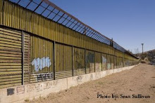
Hoping to show that he is serious about border enforcement, and to attract the voting bloc that abandoned Perry when they found out that he favored allowing undocumented students to pay in-state tuition, last fall Newt followed Michelle Bachmann’s lead and signed a pledge to line the southern border with double-layered border walls by 2013.
The pledge was written by Americans for Securing the Border, whose national chairman is the former chairman of the South Carolina Republican Party, Van D. Hipp Jr. Mr. Hipp’s push for enforcement of immigration laws is ironic, considering his own legal status. He is a convicted felon, who in 1997 pled guilty to accepting illegal campaign contributions. The Herald-Journal of Spartanburg, South Carolina, reported that, “In return for the guilty plea, the government dismissed a 14-count fraud and money laundering indictment stemming from operation of a phone sex business.”
Having lost his job with the Republican Party, Van D. Hipp is now a lobbyist and consultant for defense contractors who want to get work from the Department of Homeland Security. If Newt is elected and follows through on his promise it could mean a lot more business for Hipp’s clients.
To date, close to $3 billion has been spent on border walls. A mile of wall averages $ 7.5 million to build, though some cost much more. Levee-walls in Hidalgo County, Texas, cost $12 million a mile, with the Hidalgo County Drainage District ponying up $44 million, roughly a third of the cost. Walls through the rugged Otay Mountain Wilderness area cost $16 million per mile, and right now in San Diego $4.3 million is being spent to replace a section that runs for just 300 feet across the beach before plunging into the ocean.
650 miles, or around 1/3 of the southern border, already has either single-layered pedestrian walls or vehicle barriers. Adding another layer to the existing walls, replacing vehicle barriers with pedestrian walls, and building 1,300 miles of new wall would cost tens, and possibly hundreds, of billions more, at a time when Congress is trying to cut trillions from existing programs.
President Bush’s Secretary of Homeland Security, Michael Chertoff, oversaw the construction of most of the walls that now line the southern border. From that vantage he also saw the huge amounts of money that went into them. It is no surprise then that shortly after he left the Department of Homeland Security he founded the Chertoff Group, which helps big defense companies land Department of Homeland Security contracts. Many other top officials have quit DHS to join the Chertoff Group and cash in on their Homeland Security connections.
When the “underwear bomber” attempted to blow up a passenger plane a few months after he left DHS, former Secretary Chertoff granted dozens of interviews in which he gave advice on how the U.S. could prevent similar assaults. Again and again he said that full body scanners were the best solution. The Transportation Safety Administration, which falls under the umbrella of the Department of Homeland Security, subsequently required that airports install body scanners. Chertoff failed to mention in the first round of interviews that the company that made the body scanners was a client of the Chertoff Group. It is safe to assume that they were pleased with the return on their investment.
Hipp apparently hopes to emulate Chertoff and get his slice of the Homeland Security pie. Anything he can do to make that pie fatter, such as convincing the next president to commit to building more border walls, improves his odds of getting a piece. The hundreds of private landowners, and mile after mile of wildlife refuges, that the new walls would harm are of no more concern to Hipp than the 400 landowners whose property has already been taken or the damage walls have already inflicted on the Lower Rio Grande Valley National Wildlife Refuge were to Chertoff. In their eyes condemnations and habitat destruction are just the cost of doing business.
Of course those are costs paid by someone else; Chertoff and Hipp only reap the profits.
For Gingrich, signing Hipp’s border wall pledge is just good politics. On the one hand, it helps him look tough on immigration and border security. And following the Supreme Court’s Citizens United ruling, allowing corporations masquerading as people to spend unlimited sums on elections, cozying up to contractors who have made millions off of border security, and might like to see more contracts come their way, could prove to be quite lucrative.
Border walls are all about money and politics, not immigration or drug control. Kiewit does not have to refund the millions it was paid to build walls, even though those walls only take a couple of minutes to climb. Boeing gets to keep the huge sums that it received to build virtual fences that never worked. Like the phone sex business in the nineties, Homeland Security contracts are a sure-fire way for the unscrupulous to rake in big money, and Newt has pledged that if he is elected president the cash will keep on coming.
Showing posts with label construction. Show all posts
Showing posts with label construction. Show all posts
Monday, January 30, 2012


Friday, September 16, 2011
CBP Willing to Risk Flooding to Erect New Walls in Roma, Rio Grande City and Los Ebanos
By Scott Nicol
It was just over a year ago that the rising waters of the Rio Grande prompted the mandatory evacuation of Los Ebanos, Texas. Residents rushed to grab what they could before floodwaters cut off the town.
Before the flood, Customs and Border Protection (CBP) was pressuring the U.S. half of the International Boundary Water Commission (USIBWC) to approve the construction of border walls through Los Ebanos, as well as Rio Grande City and Roma, that could have worsened the flooding. CBP had even gone so far as to request that the US half of the International Boundary Water Commission act “unilaterally” and approve walls in the floodplain despite the objections of the Mexican half.
The plans for border walls drafted after the passage of the Secure Fence Act showed South Texas on the receiving end of 69 miles of border wall in 21 disconnected sections. The westernmost three sections, designated O-1, O-2, and O-3, were to be through the communities of Roma, Rio Grande City, and Los Ebanos.
In 2008 the US International Boundary Water Commission made it clear that any walls built along the Rio Grande must comply with US-Mexico treaties. The Real ID Act allowed the Department of Homeland Security (DHS), Customs and Border Protection’s parent agency, to waive all federal, state, and local laws, but not treaties. Walls built in the flood plain adjacent to the Rio Grande might deflect flood waters towards Mexico, causing flood damage to Mexican communities. Deflection might also cause the river to settle into a new channel farther to the south, which would effectively change the location of the US-Mexico boundary. Either of these would be a treaty violation.
In Cameron County and most of Hidalgo our treaty obligations meant that border walls could not be built between the existing flood control levees and the river, so walls were constructed on, in, or north of the levees. Those walls are, for the most part, finished. But unlike the downriver sections, Roma, Rio Grande City, and Los Ebanos do not have USIBWC flood control levees. The border walls in these three communities would therefore be in the flood plain.
Because of the wall’s likely flood impacts USIBWC rejected these three sections of border wall.
A few days after the 2008 elections CBP informed Representative Cuellar, whose district encompasses these communities, that these border wall sections were “on hold.” At the time Cuellar said, “This is a big victory.” He went on to tell the Associated Press, “We're hoping that this will allow us to work with the next president to find ... alternative methods for security."
Representative Cuellar’s constituents also hoped that that would be the last they would hear of plans to wall off their towns from the river, but in a May, 2010 report on the Secure Border Initiative (which includes both solid and “virtual” border walls) the Government Accountability Office stated, “CBP plans to construct an additional 14 miles of pedestrian fencing in the Rio Grande Valley sector.” These 14 miles are the combined Roma, Rio Grande City, and Los Ebanos sections.
Documents uncovered by the Sierra Club through a Freedom of Information Act request over the last year demonstrate that, in fact, the Department of Homeland Security and Customs and Border Protection continued to push for the construction of these walls, and were willing to disregard our treaty obligations and likely problems with flooding to do so.
A Customs and Border Protection “Fence Status Brief” dated April 27, 2009 reveals that to build the previously rejected walls CBP had decided upon a new plan. They would not change the design or location of the walls, or, better yet, give up on them entirely. Instead it says, “the new strategy involves developing a new floodplain model” and that, unlike the old model approved by USIBWC that “predicted noteworthy floodplain impacts from the fence,” “this model will demonstrate the impacts of the proposed fence will be minimal.”
The verb tense - "this model will demonstrate" - is important. It appears that CBP determined the outcome in advance, rather than commissioning an honest, unbiased model that would accurately describe the effects of structures built in the floodplain.
The “new flood plain model”, prepared by Baker Engineering, was completed in December 2009. Presented to CBP eight months after their fence status brief forecast its findings, its conclusion fit the earlier prediction precisely. The “noteworthy floodplain impacts” of building border walls in a floodplain that were predicted just a year earlier disappeared; instead, Baker now claimed that walls would have a “minimal effect on the Rio Grande floodplain.”
Baker decided this without even knowing what type of border wall design would be used. In 2008, CBP proposed a number of designs that were touted as either allowing floodwaters to pass through without being dammed up, or able to be removed before rising water reached them. USIBWC rejected all of these unrealistic schemes. In their 2009 report Baker modeled the border wall as an 18’ high, impermeable wall, with the specific design, whether concrete or steel, posts or mesh or slabs, to be determined later. Since CBP apparently told Baker what the outcome of their modeling would be before they began, it seems that such details were unimportant.
One striking conclusion of Baker’s “new flood plain model” was that in the communities of Roma, Rio Grande City, and Los Ebanos, border walls would “split” the flooding river. It states that for each wall segment, “Downstream of the flow split location, the flow continues in a north branch and a south branch on either side of the fence. The flow combines downstream of the point where the fence ends.”
This splitting is intentional. In the case of Rio Grande City, the wall was modeled with a 500 foot-wide opening in the middle specifically intended to split flood waters and send a portion of them north. Diverting water to the north of the border wall, into property on the US side of the river, means that less is deflected into Mexico. In this way CBP hopes to avoid flooding Mexican communities, and possibly pushing the Rio Grande into a new channel. Walls built in a floodplain will either deflect or divert floodwater, and the only real question is who is going to be on the receiving end.
Each of these wall sections begins upstream of a town and ends downstream of it. They begin close to the river, then the river and wall get farther apart before coming back together. So flood water that might not have reached properties where the proposed wall is farthest from the river will, with a wall in place, have “split” floodwaters channeled directly to them.
This is particularly striking for the Los Ebanos section. The community of Los Ebanos is nestled at the top of a deep bend in the river. The proposed wall would begin next to the Rio Grande at the top of this bend. While the river turns and heads due south, away from homes and the local school, the wall heads due east, directly towards them. That means that water that might have otherwise followed the river and flowed away from Los Ebanos will be split off by the wall, and be diverted into it. On the other side of town, instead of allowing the split flood waters to pour back into the Rio Grande, the wall makes a ninety degree turn, from east to north. Water that had been split off from the flooded river would therefore be bottled up in Los Ebanos.
A Customs and Border Protection Fence Status Brief dated January 20, 2010, written following the presentation of the “new flood plain model” to the Army Corps of Engineers and USIBWC, says that, “[acting USIBWC Commissioner] Ruth agreed no additional modeling is required and to ‘informally’ discuss the fence segments with the new Mexican IBWC Commissioner to determine if he will support.” The brief goes on to state that, “If it appears Mexico will continue to oppose fencing, CBP/DHS and IBWC/DOS [Department of State] to discuss potential unilateral decision to proceed with construction.”
A “unilateral decision” regarding the Rio Grande floodplain, taken by the US half of the International Boundary Water Commission in the face of opposition by the Mexican half, would be a serious treaty violation. The United States would essentially be challenging Mexico to try to stop us from building illegal walls.
On January 21, 2010, acting USIBWC Commissioner Ruth stepped aside, and Edward Drusina became the new commissioner. On his first day in office Commissioner Drusina wrote a letter to David Aguilar, the acting Commissioner of Customs and Border Protection. He stated that, after examining the model that CBP had commissioned, “the USIBWC is not in a position to approve construction of the O-1, O-2 and O-3 fence projects.”
Rather than accept the fact that walls built in the Rio Grande floodplain will have unacceptable impacts, CBP repeatedly pressed the USIBWC to reverse its decision. On February 2, 2010, Aguilar responded to Drusina, “we respectfully request that the USIBWC and Department of State reconsider your position and approve a unilateral decision to allow us to proceed with the design and construction of the O-1, O-2 and O-3 fence segments.”
On July 20, just one week after the flooding Rio Grande forced the mandatory evacuation of Los Ebanos, CBP presented a briefing to the State Department on these three border wall sections. During the briefing CBP claimed that they had already spent “+$1M in “design analysis” costs”, and said that, “we need IBWC and Department of State’s support for an unilateral decision to proceed with the fence construction.”
USIBWC stood firm, and on September 17, 2010, Comissioner Drusina again denied CBP permission to build new walls in the Rio Grande flood plain. CBP continued to push back, and a month later the new CBP Commissioner, Alan Bersin, wrote to USIBWC, asking that they reconsider and complaining about “Mexico’s recent opposition to border fencing regardless of hydraulic modeling results.”
Bersin’s October 2010 letter to USIBWC is the most recent document uncovered by the Sierra Club’s Freedom of Information Act request. The Club was told that to obtain newer documents another request would have to be filed. One has, but it may take months for us to begin receiving more documents.
We have learned through a recent conversation with representatives of the USIBWC and State Department that following the October 2010 letter Commissioners Bersin and Drusina held at least two meetings to discuss the Roma, Rio Grande City, and Los Ebanos walls. As a result of those meetings Baker Engineering was commissioned to develop yet another flood model. That model was completed last spring, and was reviewed by the Army Corps. of Engineers and USIBWC over the summer. It has not been released to the public.
While we hope that USIBWC continues to act in the best interests of the residents of these three communities and live up to its treaty obligations in the face of pressure from Customs and Border Protection, we have no guarantees. The discussions between these two agencies are being held behind closed doors, with landowners and community leaders kept out of the room. It may be months before we are able to see a copy of the latest flood model, and the only announcement that new border walls have been approved may be the arrival of construction crews.
US Representative Henry Cuellar, who represents Roma, Rio Grande City, and Los Ebanos in Washington, should ensure that his constituents are kept informed and given a seat at the table when walls that could channel flood waters into their homes and property are discussed. As the ranking member of the House Homeland Security Subcommittee on Border and Maritime Security, he has the power to demand that CBP hold open public hearings in each of these communities. Customs and Border Protection owes residents the decency of a face to face explanation, before they build new border walls that could put people’s lives and properties at risk.
It was just over a year ago that the rising waters of the Rio Grande prompted the mandatory evacuation of Los Ebanos, Texas. Residents rushed to grab what they could before floodwaters cut off the town.
Before the flood, Customs and Border Protection (CBP) was pressuring the U.S. half of the International Boundary Water Commission (USIBWC) to approve the construction of border walls through Los Ebanos, as well as Rio Grande City and Roma, that could have worsened the flooding. CBP had even gone so far as to request that the US half of the International Boundary Water Commission act “unilaterally” and approve walls in the floodplain despite the objections of the Mexican half.
The plans for border walls drafted after the passage of the Secure Fence Act showed South Texas on the receiving end of 69 miles of border wall in 21 disconnected sections. The westernmost three sections, designated O-1, O-2, and O-3, were to be through the communities of Roma, Rio Grande City, and Los Ebanos.
In 2008 the US International Boundary Water Commission made it clear that any walls built along the Rio Grande must comply with US-Mexico treaties. The Real ID Act allowed the Department of Homeland Security (DHS), Customs and Border Protection’s parent agency, to waive all federal, state, and local laws, but not treaties. Walls built in the flood plain adjacent to the Rio Grande might deflect flood waters towards Mexico, causing flood damage to Mexican communities. Deflection might also cause the river to settle into a new channel farther to the south, which would effectively change the location of the US-Mexico boundary. Either of these would be a treaty violation.
In Cameron County and most of Hidalgo our treaty obligations meant that border walls could not be built between the existing flood control levees and the river, so walls were constructed on, in, or north of the levees. Those walls are, for the most part, finished. But unlike the downriver sections, Roma, Rio Grande City, and Los Ebanos do not have USIBWC flood control levees. The border walls in these three communities would therefore be in the flood plain.
Because of the wall’s likely flood impacts USIBWC rejected these three sections of border wall.
A few days after the 2008 elections CBP informed Representative Cuellar, whose district encompasses these communities, that these border wall sections were “on hold.” At the time Cuellar said, “This is a big victory.” He went on to tell the Associated Press, “We're hoping that this will allow us to work with the next president to find ... alternative methods for security."
Representative Cuellar’s constituents also hoped that that would be the last they would hear of plans to wall off their towns from the river, but in a May, 2010 report on the Secure Border Initiative (which includes both solid and “virtual” border walls) the Government Accountability Office stated, “CBP plans to construct an additional 14 miles of pedestrian fencing in the Rio Grande Valley sector.” These 14 miles are the combined Roma, Rio Grande City, and Los Ebanos sections.
Documents uncovered by the Sierra Club through a Freedom of Information Act request over the last year demonstrate that, in fact, the Department of Homeland Security and Customs and Border Protection continued to push for the construction of these walls, and were willing to disregard our treaty obligations and likely problems with flooding to do so.
A Customs and Border Protection “Fence Status Brief” dated April 27, 2009 reveals that to build the previously rejected walls CBP had decided upon a new plan. They would not change the design or location of the walls, or, better yet, give up on them entirely. Instead it says, “the new strategy involves developing a new floodplain model” and that, unlike the old model approved by USIBWC that “predicted noteworthy floodplain impacts from the fence,” “this model will demonstrate the impacts of the proposed fence will be minimal.”
The verb tense - "this model will demonstrate" - is important. It appears that CBP determined the outcome in advance, rather than commissioning an honest, unbiased model that would accurately describe the effects of structures built in the floodplain.
The “new flood plain model”, prepared by Baker Engineering, was completed in December 2009. Presented to CBP eight months after their fence status brief forecast its findings, its conclusion fit the earlier prediction precisely. The “noteworthy floodplain impacts” of building border walls in a floodplain that were predicted just a year earlier disappeared; instead, Baker now claimed that walls would have a “minimal effect on the Rio Grande floodplain.”
Baker decided this without even knowing what type of border wall design would be used. In 2008, CBP proposed a number of designs that were touted as either allowing floodwaters to pass through without being dammed up, or able to be removed before rising water reached them. USIBWC rejected all of these unrealistic schemes. In their 2009 report Baker modeled the border wall as an 18’ high, impermeable wall, with the specific design, whether concrete or steel, posts or mesh or slabs, to be determined later. Since CBP apparently told Baker what the outcome of their modeling would be before they began, it seems that such details were unimportant.
One striking conclusion of Baker’s “new flood plain model” was that in the communities of Roma, Rio Grande City, and Los Ebanos, border walls would “split” the flooding river. It states that for each wall segment, “Downstream of the flow split location, the flow continues in a north branch and a south branch on either side of the fence. The flow combines downstream of the point where the fence ends.”
This splitting is intentional. In the case of Rio Grande City, the wall was modeled with a 500 foot-wide opening in the middle specifically intended to split flood waters and send a portion of them north. Diverting water to the north of the border wall, into property on the US side of the river, means that less is deflected into Mexico. In this way CBP hopes to avoid flooding Mexican communities, and possibly pushing the Rio Grande into a new channel. Walls built in a floodplain will either deflect or divert floodwater, and the only real question is who is going to be on the receiving end.
Each of these wall sections begins upstream of a town and ends downstream of it. They begin close to the river, then the river and wall get farther apart before coming back together. So flood water that might not have reached properties where the proposed wall is farthest from the river will, with a wall in place, have “split” floodwaters channeled directly to them.
This is particularly striking for the Los Ebanos section. The community of Los Ebanos is nestled at the top of a deep bend in the river. The proposed wall would begin next to the Rio Grande at the top of this bend. While the river turns and heads due south, away from homes and the local school, the wall heads due east, directly towards them. That means that water that might have otherwise followed the river and flowed away from Los Ebanos will be split off by the wall, and be diverted into it. On the other side of town, instead of allowing the split flood waters to pour back into the Rio Grande, the wall makes a ninety degree turn, from east to north. Water that had been split off from the flooded river would therefore be bottled up in Los Ebanos.
A Customs and Border Protection Fence Status Brief dated January 20, 2010, written following the presentation of the “new flood plain model” to the Army Corps of Engineers and USIBWC, says that, “[acting USIBWC Commissioner] Ruth agreed no additional modeling is required and to ‘informally’ discuss the fence segments with the new Mexican IBWC Commissioner to determine if he will support.” The brief goes on to state that, “If it appears Mexico will continue to oppose fencing, CBP/DHS and IBWC/DOS [Department of State] to discuss potential unilateral decision to proceed with construction.”
A “unilateral decision” regarding the Rio Grande floodplain, taken by the US half of the International Boundary Water Commission in the face of opposition by the Mexican half, would be a serious treaty violation. The United States would essentially be challenging Mexico to try to stop us from building illegal walls.
On January 21, 2010, acting USIBWC Commissioner Ruth stepped aside, and Edward Drusina became the new commissioner. On his first day in office Commissioner Drusina wrote a letter to David Aguilar, the acting Commissioner of Customs and Border Protection. He stated that, after examining the model that CBP had commissioned, “the USIBWC is not in a position to approve construction of the O-1, O-2 and O-3 fence projects.”
Rather than accept the fact that walls built in the Rio Grande floodplain will have unacceptable impacts, CBP repeatedly pressed the USIBWC to reverse its decision. On February 2, 2010, Aguilar responded to Drusina, “we respectfully request that the USIBWC and Department of State reconsider your position and approve a unilateral decision to allow us to proceed with the design and construction of the O-1, O-2 and O-3 fence segments.”
On July 20, just one week after the flooding Rio Grande forced the mandatory evacuation of Los Ebanos, CBP presented a briefing to the State Department on these three border wall sections. During the briefing CBP claimed that they had already spent “+$1M in “design analysis” costs”, and said that, “we need IBWC and Department of State’s support for an unilateral decision to proceed with the fence construction.”
USIBWC stood firm, and on September 17, 2010, Comissioner Drusina again denied CBP permission to build new walls in the Rio Grande flood plain. CBP continued to push back, and a month later the new CBP Commissioner, Alan Bersin, wrote to USIBWC, asking that they reconsider and complaining about “Mexico’s recent opposition to border fencing regardless of hydraulic modeling results.”
Bersin’s October 2010 letter to USIBWC is the most recent document uncovered by the Sierra Club’s Freedom of Information Act request. The Club was told that to obtain newer documents another request would have to be filed. One has, but it may take months for us to begin receiving more documents.
We have learned through a recent conversation with representatives of the USIBWC and State Department that following the October 2010 letter Commissioners Bersin and Drusina held at least two meetings to discuss the Roma, Rio Grande City, and Los Ebanos walls. As a result of those meetings Baker Engineering was commissioned to develop yet another flood model. That model was completed last spring, and was reviewed by the Army Corps. of Engineers and USIBWC over the summer. It has not been released to the public.
While we hope that USIBWC continues to act in the best interests of the residents of these three communities and live up to its treaty obligations in the face of pressure from Customs and Border Protection, we have no guarantees. The discussions between these two agencies are being held behind closed doors, with landowners and community leaders kept out of the room. It may be months before we are able to see a copy of the latest flood model, and the only announcement that new border walls have been approved may be the arrival of construction crews.
US Representative Henry Cuellar, who represents Roma, Rio Grande City, and Los Ebanos in Washington, should ensure that his constituents are kept informed and given a seat at the table when walls that could channel flood waters into their homes and property are discussed. As the ranking member of the House Homeland Security Subcommittee on Border and Maritime Security, he has the power to demand that CBP hold open public hearings in each of these communities. Customs and Border Protection owes residents the decency of a face to face explanation, before they build new border walls that could put people’s lives and properties at risk.
Thursday, July 7, 2011
How much do border walls cost? Just the facts:
There is a wide cost range for the construction of pedestrian border walls, resulting from factors which include labor (some sections were built by members of the National Guard, while others were built by private contractors); topography; remote vs. urban locations; land purchases and condemnations; materials (wall sections built in the 1990’s used scrap metal, obtained from the military for free, while more recent sections have required the purchase of concrete, steel, etc.); and the design that is being utilized.
In October 2008 the Houston Chronicle reported that “The Army Corps of Engineers estimated that the amount spent for pedestrian fencing has jumped 88 percent since February to $7.5 million per mile. The costs for vehicle barriers have increased 40 percent to $2.8 million per mile, according to the GAO.”
“As border fence lags, costs, controversy rise” by Stewart Powell, Houston Chronicle, October 10, 2008
http://www.chron.com/disp/story.mpl/metropolitan/6052544.html
In January, 2009, the Government Accountability Office (GAO) reported that costs for sections built up to that point ranged from $400,000 to $15.1 million. They also noted that these cost estimates were not independently verified and, “An Independent Auditor's Report on DHS's Fiscal Year 2008 Financial Statements found that CBP did not have adequate policies and procedures in place to properly account for steel purchases and construction of the U.S. border fence in an accurate and timely manner. As a result, for several months throughout the year, CBP’s financial statements did not accurately reflect the construction activity.”
Secure Border Initiative Fence Construction Costs, United States Government Accountability Office, January 29, 2009
http://www.gao.gov/new.items/d09244r.pdf
The GAO’s January 2009 report only included border wall sections that had been completed, not those which were under construction or in various stages of planning.
Sections that were later constructed included the 3.6 miles of pedestrian border wall built through the Otay Mountain Wilderness Area, at a cost of $57.7 million, averaging just over $16 million per mile.
“$57.7-million fence added to an already grueling illegal immigration route” by Richard Marosi, Los Angeles Times, February 15, 2010
http://articles.latimes.com/2010/feb/15/local/la-me-fence15-2010feb15
Also unfinished at the time were the border wall and earthen berm blocking Smuggler’s Gulch, near San Diego, which cost $59 million for 3.5 miles, averaging $16.8 million per mile.
“A Barren Promise at the Border” by Rob Davis, Voice of San Diego, October 22, 2009http://www.voiceofsandiego.org/environment/article_13330282-1245-5e49-bd68-5a10237c9f44.html
According to the GAO it will cost an estimated $75 million per year to maintain border walls. As of mid-May 2009, the fence had been breached more than 3,300 times, with costs to repair each breach averaging $1,300.
Secure Border Initiative: Technology Deployment Delays Persist and the Impact of Border Fencing Has Not Been Assessed, Government Accountability Office, September 2009
http://www.gao.gov/new.items/d09896.pdf
In 2011 the GAO stated that “CBP estimated that the border fencing had a life cycle of 20 years and over these years, a total estimated cost of about $6.5 billion to deploy, operate, and maintain the fencing and other infrastructure. According to CBP, during fiscal year 2010, there were 4,037 documented and repaired breaches of the fencing and CBP spent at least $7.2 million to repair the breaches, or an average of about $1,800 per breach.”
BORDER SECURITY: DHS Progress and Challenges in Securing the U.S. Southwest and Northern Borders, United States Government Accountability Office, March 30, 2011
http://www.gao.gov/new.items/d11508t.pdf
In the spring and summer of 2011, CBP replaced 2.77 miles of existing “landing mat” fence in Nogales, which had suffered numerous breaches, with “bollard” fencing, at a cost of $11.6 million.
“Barrier Rebuilt” by Margaret Regan, Tucson Weekly, June 23, 2011
http://www.tucsonweekly.com/tucson/barrier-rebuilt/Content?oid=3028495
In 2010 the GAO reported that “Since fiscal year 2006, DHS has received about $4.4 billion in appropriations for SBI, including about $2.5 billion for physical fencing and related infrastructure, about $1.5 billion for virtual fencing (e.g., surveillance systems) and related infrastructure (e.g., towers), and about $300 million for program management.”
SECURE BORDER INITIATIVE: DHS Needs to Strengthen Management and Oversight of Its Prime Contractor, United States Government Accountability Office, October, 2010
http://www.gao.gov/new.items/d116.pdf
In October 2008 the Houston Chronicle reported that “The Army Corps of Engineers estimated that the amount spent for pedestrian fencing has jumped 88 percent since February to $7.5 million per mile. The costs for vehicle barriers have increased 40 percent to $2.8 million per mile, according to the GAO.”
“As border fence lags, costs, controversy rise” by Stewart Powell, Houston Chronicle, October 10, 2008
http://www.chron.com/disp/story.mpl/metropolitan/6052544.html
In January, 2009, the Government Accountability Office (GAO) reported that costs for sections built up to that point ranged from $400,000 to $15.1 million. They also noted that these cost estimates were not independently verified and, “An Independent Auditor's Report on DHS's Fiscal Year 2008 Financial Statements found that CBP did not have adequate policies and procedures in place to properly account for steel purchases and construction of the U.S. border fence in an accurate and timely manner. As a result, for several months throughout the year, CBP’s financial statements did not accurately reflect the construction activity.”
Secure Border Initiative Fence Construction Costs, United States Government Accountability Office, January 29, 2009
http://www.gao.gov/new.items/d09244r.pdf
The GAO’s January 2009 report only included border wall sections that had been completed, not those which were under construction or in various stages of planning.
Sections that were later constructed included the 3.6 miles of pedestrian border wall built through the Otay Mountain Wilderness Area, at a cost of $57.7 million, averaging just over $16 million per mile.
“$57.7-million fence added to an already grueling illegal immigration route” by Richard Marosi, Los Angeles Times, February 15, 2010
http://articles.latimes.com/2010/feb/15/local/la-me-fence15-2010feb15
Also unfinished at the time were the border wall and earthen berm blocking Smuggler’s Gulch, near San Diego, which cost $59 million for 3.5 miles, averaging $16.8 million per mile.
“A Barren Promise at the Border” by Rob Davis, Voice of San Diego, October 22, 2009http://www.voiceofsandiego.org/environment/article_13330282-1245-5e49-bd68-5a10237c9f44.html
According to the GAO it will cost an estimated $75 million per year to maintain border walls. As of mid-May 2009, the fence had been breached more than 3,300 times, with costs to repair each breach averaging $1,300.
Secure Border Initiative: Technology Deployment Delays Persist and the Impact of Border Fencing Has Not Been Assessed, Government Accountability Office, September 2009
http://www.gao.gov/new.items/d09896.pdf
In 2011 the GAO stated that “CBP estimated that the border fencing had a life cycle of 20 years and over these years, a total estimated cost of about $6.5 billion to deploy, operate, and maintain the fencing and other infrastructure. According to CBP, during fiscal year 2010, there were 4,037 documented and repaired breaches of the fencing and CBP spent at least $7.2 million to repair the breaches, or an average of about $1,800 per breach.”
BORDER SECURITY: DHS Progress and Challenges in Securing the U.S. Southwest and Northern Borders, United States Government Accountability Office, March 30, 2011
http://www.gao.gov/new.items/d11508t.pdf
In the spring and summer of 2011, CBP replaced 2.77 miles of existing “landing mat” fence in Nogales, which had suffered numerous breaches, with “bollard” fencing, at a cost of $11.6 million.
“Barrier Rebuilt” by Margaret Regan, Tucson Weekly, June 23, 2011
http://www.tucsonweekly.com/tucson/barrier-rebuilt/Content?oid=3028495
In 2010 the GAO reported that “Since fiscal year 2006, DHS has received about $4.4 billion in appropriations for SBI, including about $2.5 billion for physical fencing and related infrastructure, about $1.5 billion for virtual fencing (e.g., surveillance systems) and related infrastructure (e.g., towers), and about $300 million for program management.”
SECURE BORDER INITIATIVE: DHS Needs to Strengthen Management and Oversight of Its Prime Contractor, United States Government Accountability Office, October, 2010
http://www.gao.gov/new.items/d116.pdf
Subscribe to:
Posts (Atom)